Sunday, January 28, 2018

The Galapagos Islands

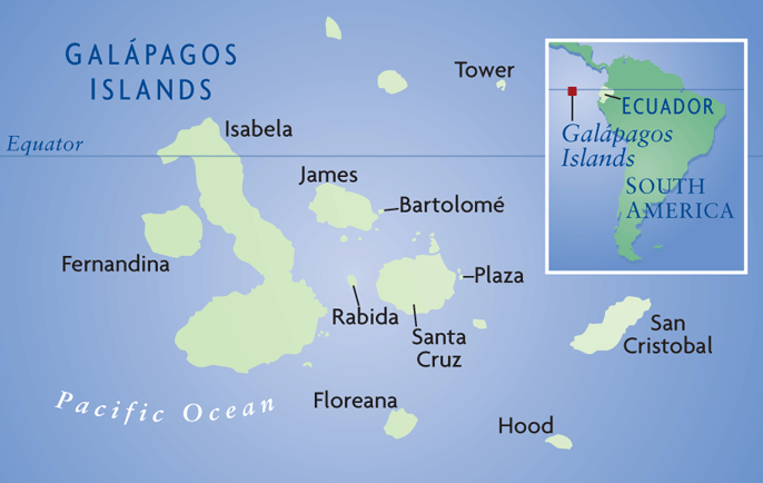
I recently returned from a five-day cruise in the Galapagos Islands aboard the ship Santa Cruz II. I was hired to give lectures on behalf of Smithsonian Journeys. It was an excellent trip all around - the weather, the sites visited, participants and naturalist crew aboard the Santa Cruz II!

The tour began in Quito the colonial capital of Ecuador (elevation 9,350 ft.). This view is from the hill called El Panecillo (the Little Loaf).

The drying laundry made for an interesting composition.

The Pre-Columbian Alabado Museum has exquisite displays and I found this sculpture of two owls fascinating.

The beautiful courtyard of the Iglesia de San Francisco. Brown-robed monks still walk the halls.

Just a few miles north of Quito lies the equator where a monument has been built. The yellow line marks the equator, which splits the building in the background.

Looking west at the Mitad del Mundo Monument (Middle of the World Monument).

I thought placing the large globe on top of the Monument in a proper orientation for this location - on its side - made for a clever and interesting perspective. I feel so fortunate to have stood at both poles of the earth as well!

Looking east from the top of the monument. The indigenous population had a celestial observatory on the hill in the background.

Finally! The Galapagos. Our first stop was on the largest island, Isabela, and this is Punta Vicente Roca on the northwesternmost spur of the island.

On this cruise we visited Isabela, Fernandina, Santa Cruz and Floreana islands. I especially enjoy this western itinerary in the Galapagos as the archipelago sits over a stationary hot spot with the islands drifting east through time over it such that the most active and recently formed islands are in the west.

At anchor, I took this picture of Fernandina Island to the south - a classic shield volcano.

The Santa Cruz II anchored at Punta Vicente Roca beneath the Ecuador Volcano. Note how dissected the volcano has become.

This is due to the crashing of large Pacific waves from the open sea to the west. The severe erosion has exposed the volcanic plumbing system here and you can see numerous dikes running upwards.

Notice the chilled margins on this dike. When the hot magma forces its way into the country rock, it cools quicker on its margins while hot magma continues to move upwards. This is a text-book example.

Check this out! Two black dikes run upwards through the gold-colored tuff and then connect to the black lava flow on top of the hill. This is a rather rare glimpse showing how the internal plumbing system of a volcanic eruption (magma) reached the surface and turned into a lava flow. Fantastic! Scroll up six images to see a wide angle view of the lava flow capping the tuff (image starting with the word "Finally!").

A marine iguana rests on a bed of volcanic tuff. Much of this point is composed of tuff which is ash-sized grains that encircle a tuff cone. Tuff cones form with the interaction of seawater and magma.

A Brown noddy (Anous stolidus) stands on a well-rounded boulder encased in the tuff. This basalt boulder was likely rounded in the swash zone along the beach, then was caught up in the eruption of the tuff cone. That is how I explained a well-rounded boulder in the tuff.

Green sea turtles (Chelonia mydas) were everywhere at Punta Vicente Roca.

Next we saw the rare Galapagos penguin (Spheniscus mendiculus), one of 18 species worldwide and the only equatorial penguin in the world. I have seen 11 or 12 species.

Close-up of the flightless cormorant on the left (Phalacrocorax harrisi) and the Galapagos penguin. I guess that since this species of penguin has made it to the equator (thus inhabiting every climate zone from polar to equatorial), there would be nothing ecologically to keep penguins confined to the Southern Hemisphere.

Moving south to Fernandina Island, I looked back at Isabela and took this photo of the Wolf Volcano.

The westernmost islands are not only good for recent geology but wildlife as well. Just offshore is the edge of the Galapagos Bank, a wall of volcanic rock that drops steeply to the west causing the upwelling of cold, nutrient-rich water. Many animals, like this marine iguana, take advantage of this upwelling and the abundance of food it provides.

Our local guides told us that this particular pahoehoe lava flow was about 500 years old.

A lava cactus (Brachycereus nesioticus) grows out of the pahoehoe.

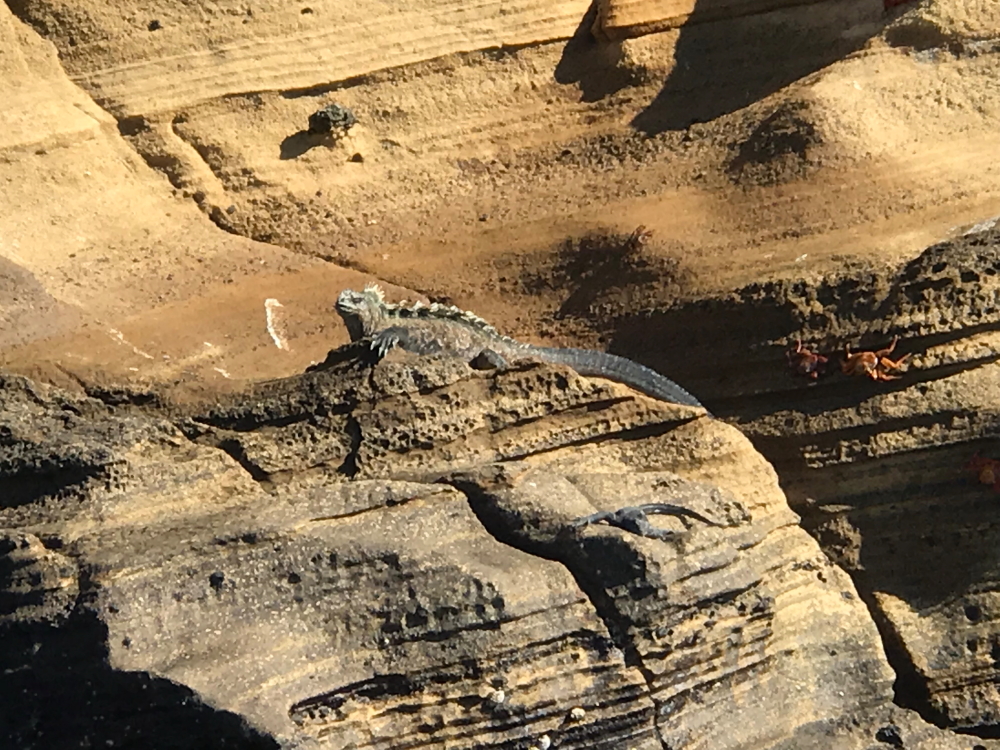
In the Galapagos you will find Earth's only marine-going iguana (Amblyrhynchus cristatus). Note the hole on the tip of its snout - they drink seawater but process out the salt and then blow it out these specialized tubes.

Close-up.

The lava flows trap water on their surface and this reflection of our group enticed me to take a shot.

A flittering Galapagos mockingbird (Mimus parvulus) brought our attention to a first for me. A Galapagos racer (Pseudalsophis biserialis) was slithering along a crack in the lava. The mockingbird may have been protecting eggs.

The Galapagos hawk (Buteo galapagoensis) posed for 1/2 an hour on a nearby branch. None of the animals here have a fear of humans.

A regal rest in the late afternoon sunlight.

Mighty claws of the marine iguana. The feed on algae that grows at the waters edge.

A land iguana (Conolophus suncristatus). See one of my previous posts here for more and better pictures of these amazing reptiles.

On Santa Cruz Island we drove into the highlands where we visited a lava tunnel. The farmer who owns the land above it has provided lighting in it but what struck me was seeing that the walls exposed layered agglutinate, blobs of airborne lava that was ejected from a nearby cone, landing while still hot such that a rootless or ventless lava flow formed. This means that the tunnel did not form from a fluid mass of erupted lava per se, but rather the still hot ejecta that flowed downhill. I had never known lava tunnels could form this way.

The big attraction in the highlands was seeing these giant tortoises (Chelonoidis nigra).

They do love the mud. I think it is cool for them.

Typical creep of tortoises. (Yep, that is what a group of tortoises is called).

Our last stop was on Isla Floreana were we visited Post Office Bay. Whalers began the tradition centuries ago, leaving letters in a barrel that would be returned home by homeward-bound whalers. I picked up three postcards to mail to Nebraska, Prescott and New Zealand. I left two to be mailed to Arizona and California.

Checking the postcards for possible return home.

Volcano along the shores of Floreana Island.

The Devil's Crown - an eroded volcano just offshore.

Blue-footed boobie (Sula nebouxii) on Floreana Island. Males display these colorful feet to attract females.

A Galapagos beach at sunset.

A lagoon on Floreana Island.

Sunset.

Our naturalist crew was one of the best I have ever worked with! From left they are Indira, Mari, Fatima, Desiree, Ricardo, Veronica, Sebastian, and Nessi.

Thanks as always for reading! Next stop - Death Valley in February.

Friday, January 12, 2018

Antarctica Aboard Le Lyrial

The new year found me once again on the White Continent! I agreed to serve as a geologic lecturer with Abercrombie and Kent on the ship, Le Lyrial. She is a beautiful vessel only 3 years old and taking the seas quite smoothly. We enjoyed two relatively calm crossings of the Drake Passage and had plenty of sun during our five-day stay. One day however, we saw wind and snow - on what would be the July 3 equivalent calendar date in the Northern Hemisphere. This was my 33rd trip to Antarctica and I don't think I can ever stay away for very long.


Ushuaia, Argentina, the world's southernmost city, is the jumping off place for most Antarctic expedition cruises. The city is located on the shores of the Beagle Channel and the international boundary with Chile runs through the middle of the channel at this location.

Our first stop was at a highly eroded volcano called Brown Bluff. The isolated knob may be a vent for the volcano, the cliff face on the right does contain pryroclastic ejecta that thins away from the knob.

On all landings survival gear is brought ashore in case of unscheduled stays!

Adele penguins (Pygocelis adeliae) go for a swim while Le Lyrial remains anchored offshore.

A penguin strolls in front of a large boulder that came down from the cliff above.

Lichens give this rock a colorful "glow" but beneath the lichen is also gold-colored pyroclastic ejecta. This color and texture indicates that the rock is palagonite, an eruptive form of basalt that indicates quenching in the presence of water. Since Antarctica was once more heavily glaciated in the Ice Age, Brown Bluff may be a sub-glacial volcano. Imagine a volcano erupting beneath a thick sheet of ice! In August of 2017, a group of UK researchers documented the presence of 91 sub-glacial volcanoes in Antarctica. As one of Earth's seven continents, there is no reason why there should not be volcanoes here - they are just buried in ice! Read about their finding here.

Leaving Brown Bluff, we entered the Antarctic Strait where huge tabular icebergs are often found. These are broken off of large ice shelves located east of the Antarctic Peninsula that ultimately drift north and west into the Strait.

Le Lyrial anchored off of Half Moon Island in the South Shetland archipelago.

Morning mist as seen from Half Moon Island.

Deception Island is the most interesting volcano in the Antarctic Peninsula region and last erupted in 1970. This tuff cone is located outside of the famous flooded caldera known as Port Foster.

Once inside Port Foster, we landed at an old whaling station and hiked to Neptunes Window. The gold-colored palogonite strewn-about here also indicates an eruption beneath a former ice sheet.

Palagonite boulders awash in a sea of black scoria from the 1968 eruption on Deception Island. There were three eruptions - 1967, 1968 and 1970. The volcano is considered active. Spanish and Argentine stations located on the shores of Port Foster regularly monitor magma movement with seismometers.

A beautiful summer morning view of Ronge Island off of the coast of the Antarctic Peninsula.

Another view of Ronge Island. The amount of glacial ice is impressive!

Ice cups, as seen on the surface of this iceberg, form when previously submerged portions of the berg roll over and become exposed to the air.

Wildlife is abundant in the Antarctic and here a Leopard seal (Hydrurga leptonyx) yawns while napping on an ice floe.

The crabeater seal (Lobodon carcinophaga) actually eats krill, a shrimp-like zooplankton that holds the most mass of any species in the Southern Ocean.

Gentoo penguins (Pygocelis papua) appear to lead the way for these red-coated bipeds (Homo sapiens antarctensis).

Late eventing light at the entrance to the Lemaire Channel.

Uma Peaks stand as guardians at the north entrance of the Lemaire Channel.

View to the south down the length of the Lemaire Channel at sunset.

A closer view. The local time is about 10:30 PM.

Many people were on deck for this transit, which did not end until after midnight. Our furthest south on this voyage was a little over 65º south.

The next day was very cloudy with light snow falling.

But it did not keep us from enjoying a morning glass of champagne. Le Lyrial sails under the French flag and the grape products were outstanding (or so I heard from beyond my beer mug).

A grounded iceberg is elevated above the water line at low tide. Melting of the icebergs is more prominent to portions in the upper water column this time of year.

While cruising by Zodiac in Charlotte Bay, someone noticed humpback whales frolicking in the snowfall. Fin-slapping has been shown to be a form of communication between whales that are just arriving or leaving from the group.

These humpback were very curious about us and seemed to come over to have a look.

Sure enough, I was driving the Zodiac, standing in the stern with my hand on the tiller when I noticed that one of the whales was swimming directly beneath us. You can also see the ruffled water and misty breath from the whale at the bottom of the photo. Wow!

When the whale arches its back for a deep dive, it usually indicates that the fluke is soon to appear above water.

There they go!

This gives a sense of what we experienced - just fantastic! Another day at work.

We were also able to visit the Eduardo Frei research station located on King George Island and operated by the government of Chile.

This is the place where in the 1980s, Chile sent a wedded couple to conceive and birth a child, hoping to serve notice that the land is sovereign to the Chilean nation. Here is the bank located at the station.

There is also a display of fossil trees found on King George (and nearby Livingstone) Island(s). The trees date from the Paleocene-Eocene Thermal Maximum, about 54 million years ago, when Earth's average temperature was about 15ºF warmer than today. At that time there with no ice at either pole and King George stand would have contained forests similar to those found in southern Patagonia today.

Next door to Eduardo Frei Station is the Russian station of Bellingshausen, where in 2004 the Holy Trinity Eastern Orthodox Church was consecrated.

Votive candle altar at the entrance to the church.

Our last stop on Penguin Island was made on a beach full of well-rounded boulders.

This is one of the only two flowering plants found in Antarctica, Deschampsia.

Hiking up to the scoria cone with Le Lyrial in the background.

Many of us walked around the perimeter of the summit crater, seen here in this panoramic shot of Penguin Island. The name really baffles me -in this area there are literally hundreds of penguin breeding colonies but only one recently erupted and perfectly preserved scoria cone.  So they call it Penguin Island? Come on! It's Scoria Cone Island to me!

Perhaps not visible in the pano shot above is the resurgent cone found on the floor of the larger outer cone. A possible vent tower or fumarole stack is seen to the left. I got to hang out here for 3 hours explaining to volcanology to anyone who listened.

Close-up off the inner crater on the floor of the summit crater on Scoria Cone Island.

One of our guests found this unusual feature on the summit and I surmised that it might be a squeeze-up that was extruded into very cold air (winter), causing it to harden quickly while more wet material pushed it aside. If it formed on a slope, then the "frozen" squeeze-up might roll over on the downhill side. Using this interpretation, the inner part of the roll is the older part.


Looking across to the northeast corner of King George Island as we prepare to return to South America. This was an excellent trip! Next week I'll be blogging from the Galapagos.