After a good nights rest, we were at it again by 8 AM. Every morning Fernando our guide would give the call for coffee at 6:30. Then at 7:00 was breakfast and by 8:00 we would be in the saddle. I opted to take the morning trip but then stayed in camp when the afternoon trip went to Cueva San Julio. I had previously been in Arroyo Santa Teresa in early 1992 and had seen San Julio. And as this was a trip with very little down time, I wanted to have some time to myself. But in the morning...
We rode the mules back into a side canyon but when the going got too steep, we were required finish the climb on foot. One of the
vaqueros had to cut vegetation away from the tail with his machete. This signaled to us that this next alcove was not regularly visited. Overnight or two-night trips into Arroyo Santa Teresa are not all that uncommon these days but that gives only enough time to see a few of the alcoves. Our trip allowed for more thorough investigations.
Orlando is a professional botanist of some note in Alta California and the smile on his face gives away the delight he had in seeing the fecundity of the super bloom from hurricanes Rosa and Sergio, just three weeks and five weeks before our arrival. It truly was an amazing display that might only experienced every decade or so.
We finally arrived at Cacariso, tucked into a side canyon off of Arroyo Santa Teresa. The slope that we descended on mules the previous day can be sen on the far left.
At little-known and little-visited Cacariso alcoves viewed a a very nice set of rock art elements.
Note the "pallet" upon which the rock art is placed - a course-grained ignimbrite. You can read about ignimbrite
here but generally these are fiery hot ash flows with suspended particles of any size that flow away from a volcanic eruption at very high rates of speed, in events known as
pyroclastic flows. The two included links with this photo will give the reader much information about how the rocks of the Sierra San Francisco were formed.
At nearly all of the rock art sites, some elements seemed to have been placed purposely at angles in the rock with part of the image on a roof and part on a wall. This photo gives a good example of this tendency. Most researchers think this holds meaning, but what it might be remains elusive.
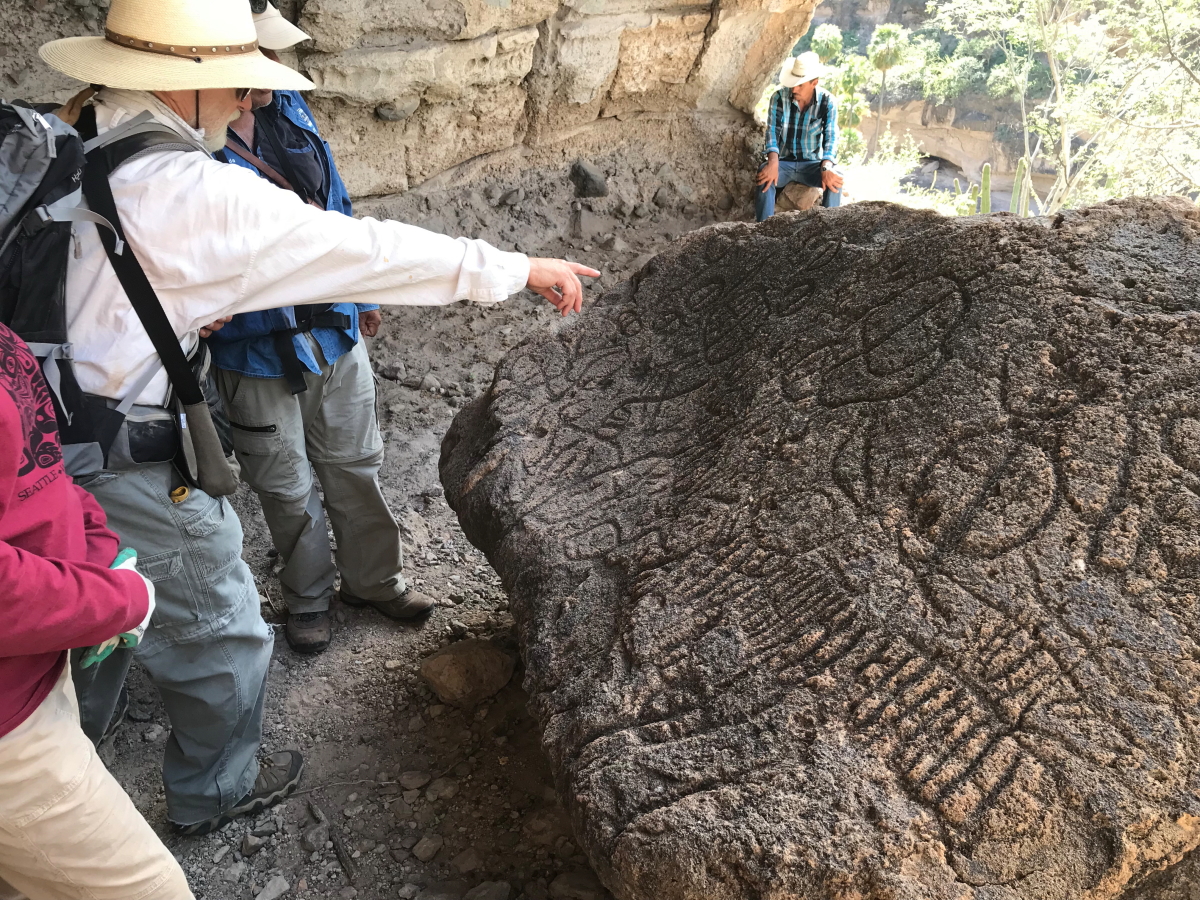
Our next destination was to the only known petroglyph site in the range. This was only "discovered" about four years ago when a local
vaquero was looking for goats.
This boulder is found on the floor of a small alcove and is of a much different rock type than the walls of the alcove. Therefore, the boulder likely originated as a clast within the finer-grained ash deposits here, but weathered out and fell to the floor of the alcove. The cave painters then chiseled numerous elements into it.
There are numerous geometric elements on the rock but curiously no animalmorphs, except for maybe the parallel lines on the right which may represent a turkey vulture (see the following descriptions below at Cueva Pintada). Our guide told us that the circles with lines through them (seen most readily on the left) might signify feminine vulvas, representing the creators desire for successful fertility within the group. Similar elements in the American Southwest are thought to represent the finger holes on an atlatl or spear throwing stick.
The beautiful Mexican blue palm growing on the floor of Santa Teresa Canyon near our camp. This ended our fourth day in the Sierra.
Day 5 saw us visiting some of the most important road arty sites in all of the Sierra. On our way, a young strangler fig (
Ficus palmeri) is seen taking advantage of a bedding plane within the rocks. Note the small alcove behind the tree forming along the same bedding plane. The alcoves in this range have formed almost exclusively along such planes where groundwater finds easy access to the surface. As the water flows out, it weakens and erodes the upper layer and through time, the alcoves become larger.
This alcove-forming process is no better illustrated than in this wide-angle view of Cueva Pintada, thought to contain the largest collection of cave paintings in the entire range. Note the bedding plane that runs along the floor of the alcove and the arch-like erosion to create the alcove in the cliff above.
When I visited this area in 1992, there was no infrastructure whatsoever in these caves. But the following year, 1993, UNESCO (the United National Educational, Scientific and Cultural Organization) declared the area to be a
World Heritage Site. Due to the increased awareness and visitation that followed, and the desire to protect the paintings, suspended walkways were installed in the following year, 1994. Here you see Fernando leading us into Cueva Pintada on such a walkway. Day 5 was a non-mule day.
What a sight to behold! An obvious black deer looks to be placed on top of a less obvious deer that is facing in the opposite direction. Just above Orlando's head are depictions of birds, likely turkey vultures or eagles that still soar above the canyons. Faint anthromomorphs can also be identified.
A closer view of the same panel. The obvious hole in the face of the rock was certainly present when the art was being made, as some of the paint can be seen coating the edges of the depression.
A closer view of the bird forms on the rock face.
Numerous fainter forms can be seen as well.
This is an interesting set of elements. Perhaps most obvious is the deer with its large ears near the top. Superimposed over it (or is it under it?) a land tortoise with its four limbs and digits clearly visible. It body is depicted as concentric circles over the body of the deer. The following elements have been identified at the more than 400 cave sites within the protected area:
rabbit, puma, lynx, deer, Bighorn sheep, whale, turtle, tuna, sardine, octopus, eagle, turkey vulture and pelican.
By now we had become familiar with the major motifs displayed in the Sierra San Francisco. If you have the time, please read
the citation recommending the inclusion of this area as a UNESCO World Heritage Site. I can also recommend watching this three-minute video created by UNESCO of the features of the area
here.
A last look at remarkable anthropomorphs in Cueva Pintada.
Our Mexican
vaqueros and guides take a break while we visit Cueva Pintada.
Across the arroyo, is another alcove named La Flecha. We will visit there in the afternoon.
But first, we need to scale a cliff to access Cueva La Soledad. There were good hand and toe holds so it was no problem for those in our group. But we could tell that not all of the clients these guides take on this excursion were as nimble.
This is Arroyo Soledad. If you have been reading these postings from the start, you may recall that on day 1 we looked into this gorge from above as we made our way from right to left toward San Gregorio. Note that the floor of this canyon is filled with the Mexican blue palm.
Approaching the alcove through the ocotillo and elephant trees.
I've only included one image from this cave but there were many worth photographing. Here a deer seems to be pierced with an arrow or spear.
Another view of Soledad Canyon.
At the junction with Santa Teresa Canyon are numerous large and deep pools of clear water.
Another pool, another temptation.
This is the small spring where our guides obtained our drinking water for three nights and eleven people. The spring is located about 1/3 of mile upstream from our camp and once a day a
vaquero would hike up here and fill a 30 liter can with fresh water. A reed has been split in half to provide an easy funnel system.
Beautiful Arroyo Santa Teresa and its palm trees.
Cueva La Flecha (Arrow Cave).
An elegant Bighorn sheep is superimposed over anthropomorphs in La Flecha.
Note the head dress on these anthropomorphs.
These are some of the best anthropomorphs and deer seen on the whole trip. This ended day 5 on our trip. We went back to camp and prepared for our exit the next day.